With a general plan in place I then had to work out some of the additional details, the most important one being where would I be sleeping every night. I’m fine with camping anywhere but do need to know where I’d be sleeping for a given night. Also, the plan was to spend my time on Manitoulin Island at a campgrounds with a dark sky preserve. They had campsites available on the 2nd and 3rd nights but the fee for the sites was something like $130 per night because they were bigger sites that could accommodate more people. However if I reserved for the 3rd and 4th nights then it was a more normal $50-something. As an aside it is kind of mind blowing that it costs $50 to get a campsite now. I guess reservation fees just go up every year and this is where it ends up. So I decided I’d change the plan to take 3 days to make it up to Manitoulin Island, have the 1 rest day there, and then 3 days to come back down. The rest day there was mandatory because the campground on Manitoulin Island had a minimum 2-night stay policy during the peak of the Perseid meteor shower. Now I needed to plot out my other days so that I could book campgrounds, or find Crown land to camp on, for the other nights.
The GNBR maps have annotations for places to stay including campgrounds, private listings, people willing to offer space to camp for free, and spaces suitable for stealth camping. The idea of stealth camping is neat but my worry would always be someone waking me in the middle of the night telling me to leave, so I’d only do that as a last resort. In my initial plan to get to Manitoulin Island in 2 days I was going to camp overnight in Owen Sound. Now that I had the extra day it made sense to find somewhere a bit further up the Bruce Peninsula and I decided that somewhere around Sauble Beach would be nice because then I could swim and hang out at the beach as well. Thankfully Sauble Falls Provincial Park had a site available for the day I wanted so that was easy. For my first night I’d need something between Orangeville and Owen Sound and there wasn’t a whole lot there, but on the GNBR maps there was a note that Crown land camping was available by Hoggs Falls which would be a good place to stop as it would take me to around 130km for the day.
For the way back I knew that the last train from Barrie to Toronto left at 9:10 pm but there was also a bus that left at 11:00pm so there was no worry about getting to Barrie too late and being stuck there for the night. I ended up deciding to stay at a city campground in Lion’s Head for night 5 and then a private campground between Owen Sound and Meaford for night 6. With my start and end points for the days all worked out now I needed to fill in details for where I’d be getting my meals. In bigger places like Owen Sound or Tobermory there would be many available options but in smaller towns there may only be one or two, and sometimes I wouldn’t be near one when I wanted to have lunch for example, so using the route and Google Maps I then made a schedule with my distance for the day and where I’d be getting all my meals:
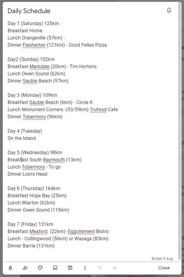
It isn’t the most detailed schedule but it gives an idea of how long my day will be and where I’ll be stopping for food. I planned on keeping snacks with me so that it wouldn’t be a big issue if a meal was a bit later than scheduled and for water I’d have 3L in my hydration pack and 1.5L in my bottles which would be more than enough to get me to my next meal.
So with the route and dates all finalized the last thing to make sure was that I had all the stuff I’d need for my trip.
